

Since most National Parks have opened back up, we are going to break our silence on travel blogging. This story is from a trip we took before the virus hit, but could easily be pulled off with masks and social distancing.
On this recent road run to see David’s father and celebrate his ninetieth birthday we came up with a plan to get the most out of our National Parks pass while driving cross country from California to Kansas.
 Taking a slightly longer route up Interstate 15 to I-70 took us through Utah and right through some of America’s most scenic landscapes, much of which has been set aside for protection as parkland.
It also happened that the areas along our way were all easily accessible by car, meaning that we could catch all of the major vistas without too much hiking, and no camping. This meant that our amazing visits only ended up adding about one day to our total travel time.
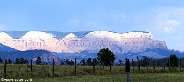
Our first stop was one of America’s most popular parks. It is also one of our oldest, created in 1909 when President William Howard Taft’s proclaimed it Mukuntuweap National Monument.
In 1917 the newly created National Park Service proposed changing the name to Zion, which was the name used by the local Mormon community for the fifteen mile long canyon. So in 1919 the monument officially became Zion National Park.
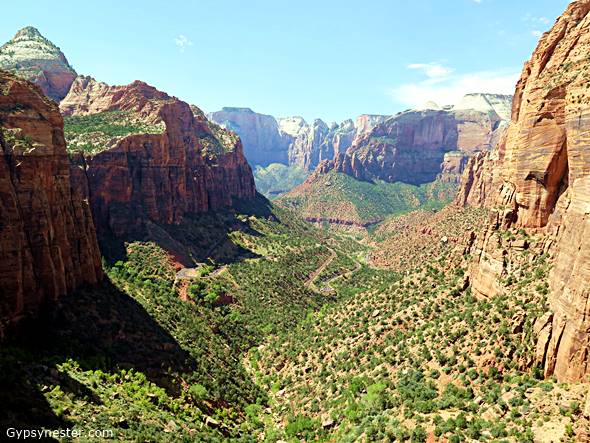
In keeping with our driving theme, we took the incredible Zion – Mount Carmel Highway, also known as Utah State Highway 9, across the southern portion of the park. Admittedly, doing this meant missing a lot along the Canyon Scenic Drive, but it kept us on track for our travels and still provided unbelievable views of the canyon and rock formations as we drove.
These were once old wagon roads, and then upgraded for automobiles beginning around 1910. No doubt they are better now, but they can still certainly be described as hair-raising.
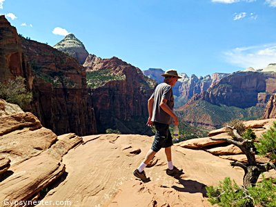 Not wanting to miss out on the thrill of hiking at least a little bit in these mountains, we stopped just as we exited the eastern entrance to the famous single lane tunnel to walk the Canyon Overlook Trail.
This one mile hike is listed as moderate, and we would agree with that rating as long as you don’t have any issues with walking right on the edge of some pretty serious drop offs. At the top we were rewarded with a view of the entire canyon dropping down over half a mile deep.
From the hike we drove through the park to the eastern exit and then on to Bryce Canyon, a little over an hour’s drive to the north.
 The name might be a tad misleading, since the big attraction of the park isn’t really a canyon in the classic sense. It is actually the weathered edge of the Paunsaugunt Plateau which has been carved up by the forces of wind and water (both liquid and frozen) over the millennium.
Bryce began as an offshoot of Zion and didn’t become a separate national park until 1956, and like Zion it is also very drivable. One main road runs along the edge of the plateau and has just over a dozen pull offs for viewing and short hikes.
Moving in order from the entrance we first came to Sunrise Point and Sunset Points, which provide opposite views of the same group of aptly named hoodoos that stand like a choir of stone statues along the cliff faces.
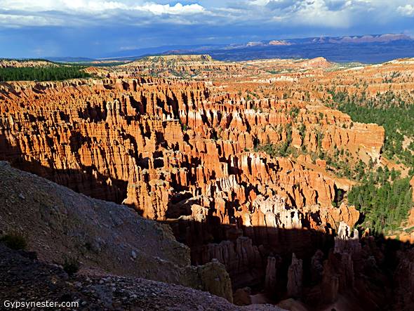 These formations are caused by erosion, usually from multiple sources. At Bryce the hoodoos are mostly the result of freezing and thawing as much as two hundred times a year. This cracks away the softer rock, but leaves behind the harder layers that top off these pinnacles. Rain also adds to the carving, as does the wind.
At Inspiration Point we then found an even bigger band of these crazy characters filling what is known as the amphitheater. The scene struck us as fitting since they looked very much like a crowd gathered for a “rock” concert.
Moving on we drove through a large pine forest, where the deer and the antelope play, before stopping at another pull off for a look at Natural Bridge on our way to the huge panoramic view at Rainbow Point.
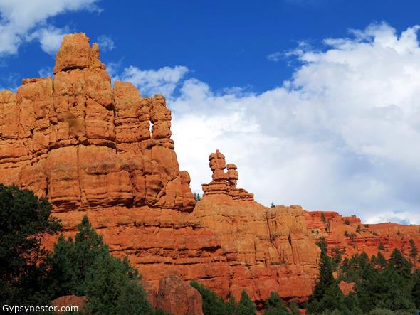
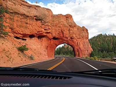 On our way out, just outside the confines of the park, Red Canyon in the Dixie National Forest gave us one last thrill.
Perhaps if it wasn’t so close to Bryce this would be a park in its own right, but even as it is the spectacular red sandstone spires and formations are said to be the “most photographed place in Utah.” It is easy to see why, with the brilliant red soil contrasted with the green pines made for a near perfect close to an amazing day.
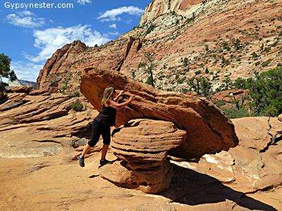
After spending the night in Panguitch, Utah, we continued the next day on to Arches National Park. While these incredible sandstone structures have been federally protected for over one hundred years, it wasn’t until 1969 that this became a national park.
 This is another very drivable park, but after the better part of three days in the car we were ready for a bit of hiking. It also happens that one of the park’s most famous features is not visible from any road. That would be Landscape Arch, which worked out well for us since the trailhead leading to it is at the very end of the road through the park.
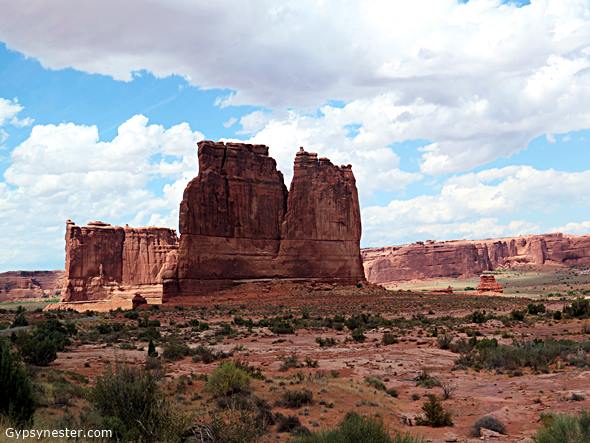
That way we didn’t miss a thing, meaning we made stops at several other spectacular spans along the route. But let’s go back to the beginning. Soon after entering the park we discovered that many of Arches coolest formations aren’t actually arches after all.
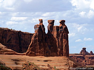 Our first stop, The Courthouse Towers Viewpoint, didn’t have an arch anywhere in sight. Instead, we found ourselves among a gathering of stone figures resembling various people and objects. All of these were fun, in a gazing at clouds to see what we see sort of way, but the Thee Gossips was definitely our pick of the litter.
This is not to diminish the fun forms of Sheep Rock, The Organ, the Tower of Babel, and of course, the courthouse itself. Any of these would be massively impressive on its own, so the combined effect of the group is quite a sight to behold.
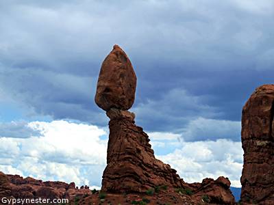 Crossing an alien looking landscape known as the Petrified Dunes we then came to the precariously positioned Balanced Rock.
There are a few of these improbable looking boulders scattered about the park, and no doubt have been many more through the ages that ultimately gave in to the forces of gravity, just as this one will sooner or later.
In fact, everything in the park is slowly disintegrating from the forces of the same erosion that created them.
 Heading down a short spur off the main road, we detoured over to The Windows. These, along with the free standing Delicate Arch, rival Landscape Arch for the position of top icon in the park.
And speaking of Landscape Arch, it was time to forge ahead to the Devil’s Garden and the trailhead for our hike.
Landscape Arch certainly seems more delicate than the one with that name, the thin band of sandstone looks as though it will give way at almost any time. In fact it has. In 1991, a 73-foot chunk came crashing down… and people were there to see it.
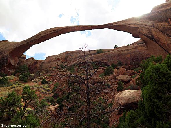
Guess that means it did make a sound.
It also means that you might want to hurry up to see it before the rest of it topples down.
David and Veronica, GypsyNester.com

Utah’s national park offers great picturesque sceneries and landscapes. It’s also an ideal place for a perfect weekend getaway. Will visit there soon, thanks for the helpful guide, keep it up.
Great post. Kept me engaged till the end.
You share nice information helpful for every reader i hope you always post information like this.