

After the seemingly endless trek across the windswept northern prairie, the landscape suddenly changes.
On second thought, “suddenly hardly” describes it.
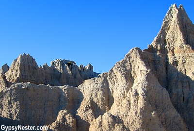
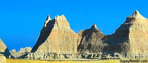
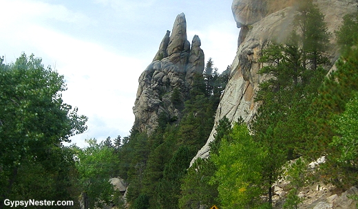
Abruptly, immediately, instantaneously the topography dramatically goes from flat grassland besieged with billboards to the spectacularly gnarled Badlands.
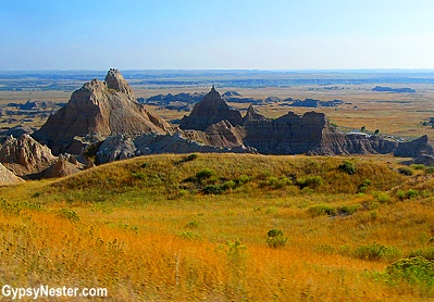
Out of nowhere the South Dakota plains give way to layers of soft shale, clay and limestone that wear away at a rate of about an inch a year leaving stunning silhouettes and fanciful formations.
See more photos of The Badlands
The Lakota Sioux dubbed the region “Mako Sica” or “Bad Land” and the early French Trappers concurred, calling it “les mauvaises terres a traverser” meaning a bad land to cross.
No one said anything about it being a bad land to LOOK at, so America recognized it as a uniquely beautiful spot and proclaimed it Badlands National Monument in 1929.
However inhospitable or difficult to traverse this place may be, the Badlands certainly provide a most unique spot where one feels utterly removed from the rest of the planet.
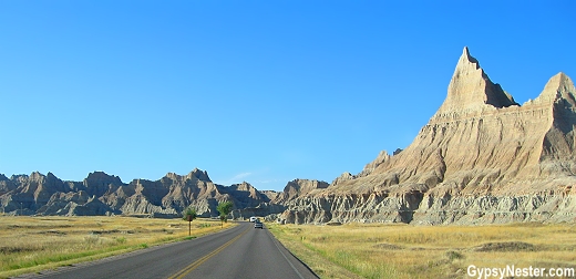
While most of the park is wilderness and inaccessible by vehicle, The Badlands Loop Road passes through the most far-fetched of formations. Absolutely remarkable — we’d go so far as to describe it asout of this world.
See more photos of The Badlands here
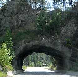
Leaving The Badlands behind us, we began the climb up into The Black Hills. Hills is a bit of a misnomer, these massive mountains rise over 7000 feet with sheer rock cliffs and beautiful forests.
We thought we were on a quest to see Mount Rushmore but found much more. The area is filled with an interesting, if a bit unsavory, history. We rapidly discovered that the disputes of the Old West rage on and that an extraordinary work of art can have an unseemly creator.
This mountain range that the Lakota Sioux call Paha Sapa, is a microcosmic study of the overall deceitful treatment the North American native peoples received from our government. Ownership of the area is still disputed based on the terms of the 1868 treaty of Fort Laramie.
Back then no one had much use for the area, except the Lakota, who lived
and hunted in the region and considered the Black Hills sacred ground. The U.S. government signed an agreement giving the tribes permanent ownership of the region.
Unfortunately for the Sioux, gold was found in them thar hills in 1874 and the prospectors flooded in.
By 1877 the great white chiefs in Washington decided Treaty? What treaty? and the army drove the Sioux out of the Hills and onto the nearby prairie.
New treaties were signed, then broken again and again throughout the following decades, until the Sioux were finally left with nothing but a few scraps of worthless flatland.
The battered Sioux Nation never gave up the fight, finally winning a court award of $17.5 million (the value of the land in 1877) plus $105 million in interest (5% for 103 years) in 1980.
The Lakota Sioux refused the judgment and continue to demand the return of their land.
This story is sadly familiar, repeated time and time again across the continent. It was easy as 1, 2, 3.
1. Sign treaty giving ownership of thought to be worthless land to a tribe or tribes in perpetuity.
2. Discover gold, silver, oil or any other use for the land.
3. Move tribes to new piece of even more worthless piece of land.
Lather, rinse, repeat.
This sad tale was followed by the creation of one of America’s greatest works of art, Mount Rushmore, but not without controversy of its own. In 1923, after removing all of the Native Americans and most of the gold from the Black Hills, historian Doane Robinson thought that an enormous something should be done to promote tourism.
See more photos of Mount Rushmore here
Robinson asked noted sculptor and Klansman (as in KKK), Gutzon Borglum, to carve a tribute to America’s first 150 years into the side of a mountain.
Gutzon happened to be available, due to a falling out with his Klan buddies regarding the depiction the heroes of the Confederacy during his Stone Mountain project in Georgia.
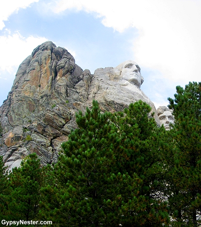
Borglum came to the Black Hills to scout out an acceptable site for his masterpiece and selected the 5,725 foot high Mount Rushmore, named for New York industrialist Charles E. Rushmore who had mining interests in the hills.
Politics, bigotry and secret society memberships aside, ol’ Gutzon sure could carve rock on a grand scale.
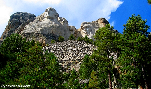
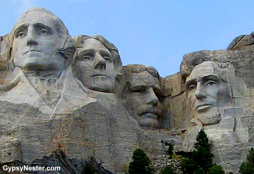
In 1925 Congress authorized funds for the project and in 1927 Borglum and four hundred workers began chipping away with everything from dynamite to tiny hand tools on the four sixty foot faces.
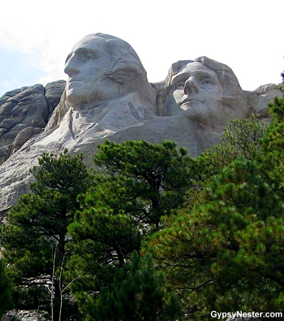
In 1933 the National Park Service took control of the monument and by 1934 the first face, Washington’s, was finished and dedicated. Jefferson followed in 1936 and Lincoln in 1937.
There was some talk in congress of adding Susan B. Anthony’s likeness to the monument but with limited funds, Roosevelt’s face was the final one, dedicated in 1939.
Work came to a halt
with Gutzon Borglum’s death and the beginning of World War II in 1941.
The end of work did not bring an end to the disputes. In 1971 members of the Sioux nations occupied the monument, hung a drape over the faces and renamed it Mount Crazy Horse.
Despite the controversies, this is a great work of art celebrating great presidents.
The main entrance to the monument leads up The Avenue of Flags to the museum and Grand View Terrace. The path is lined with tributes to every state and territory in the union, marking the date of their admission.
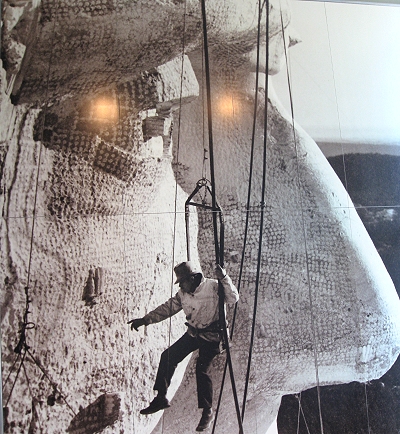
As we proceeded under the flags, gazing up at the mountain, the grandeur of the sculpture really hit us. Photographs simply do not do it justice. The view from the Terrace truly is Grand (well named guys!) and the museum offers a fascinating look at the construction methods and history of the monument.
Deciding we needed a closer look, we headed up the Presidential Trail that proceeds to the base of the faces. Well worth the climb, standing among the piles of fallen rock, cast-off from the carving, we were rewarded with views right up the nostrils of America’s greatest leaders.
At the end of the trail we found The Sculptor’s Studio where Gutzon Borglum’s tools, drawings and clay model of his original concept to depict the presidents from the waist up are on display.
The idea was probably overambitious and honestly, we think it fits in with the surrounding landscape better in the unfinished, smaller version.
See more photos of Mount Rushmore here
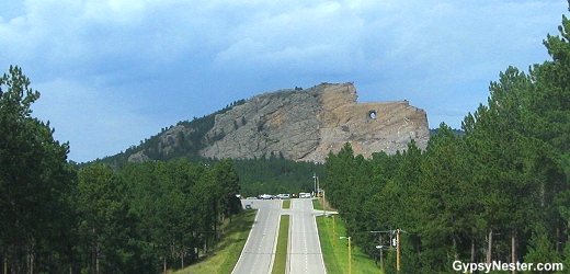
During the work on Rushmore representatives from the Sioux Nation approached Korczak Ziolkowski, who was working with Borglum, with the idea that perhaps some of the greats from their past should be memorialized as well.
They chose Thunderhead Mountain, eight miles from Rushmore, and began work on the Crazy Horse monument in 1948. Entirely funded from private donations, the ambitious work has been slow and not without some controversy of its own.
Many natives feel that the sacred land should be left alone. Ziolkowski died in 1982 but his wife and children remain involved as the project forges ahead.
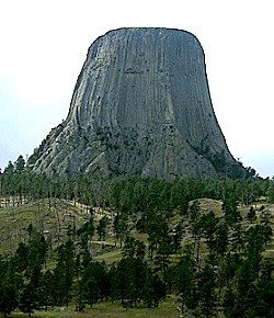
Since we were in the vicinity, a drive over to Devils Tower National Monument was in order.
Just across the border into Wyoming, the tower is probably best known for its role as the meeting place in the movie Close Encounters of the Third Kind.
In real life it’s not made of mashed potatoes, but from volcanic rock left exposed after the softer materials around it eroded away.
The Tower’s odd vertical markings come from the way the lava crystallized as it cooled or perhaps from the scratching of giant bear claws. The stories from geologists and Native American legends seem to differ on this point.
Numerous tribes believed the 5,112 foot high monolith bears the markings left by a giant bear trying to reach the top of the Tower.
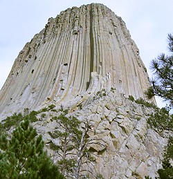
The park has numerous trails ranging from easy hikes to straight up the tower.
We wisely picked The Tower Trail which, despite the name, goes around the base of the tower and not up the side.
We did get to watch some other maniacs scending the sheer cliffs while we strolled along humming the five note opus from Close Encounters.Dooo – doo – doo – doo – doooo.
It’s a terrible chorus to have stuck in your head, believe us. Just the same five notes over and over and over. And over.
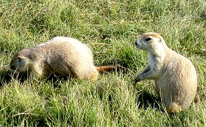
We managed to extract the refrain from our brains by visiting the prairie dog town on the south edge of the park. These little guys can take your mind off of anything.
Adorable and amusing, we spent at least an hour just watching their antics. But alas, the time had come to move along.
Turning back for one last look at the tower as we drove away… DAMN!… there it is again. Those same five notes. We didn’t ask around, but I’ll bet it wasn’t just us. I’d bet everyone who has seen the movie is cursed with those five notes as soon as they see the Devils Tower.
Dooo – doo – doo – doo – doooo.
David & Veronica, GypsyNester.com
Fabulous information! Thank You!!
Hi gypsynesters .hey got a question. In August we will be leaving mt. Rushmore going to yapiti Wyoming, just west of Cody. Wondering what the best route would be. Concerned about steep mountains. We got a 35foot mtr. Home ,pulling a car on a tow dolly. Thanks
Hi Vernon. We haven’t driven that route before so aren’t experts, but US 14 should be a good road and the mountains don’t get too big until west of Wapiti. Have a fun and safe trip.
Dooo – doo – doo – doo – doooo.
It’s a bit corny, but Wall Drug is a worthwhile stop just outside the Badlands. I also like Custer State Park on the north side of the Black Hills. It has a nice Buffalo herd. The train, gold panning (and ice cream stops just about anywhere) are good for the kids. There are lots of great campgrounds. We’ve had two if our best family vacations in the Hills.
So true, a lot to do in the area.
>sounds wonderful
>just enjoyed a great summer vacation with my 11 yr old son and grandparents seeing all of these places, totally awesome and beautiful….we both hated for it to end
Way to make some good memories!
>I recall when my cousin didn't let go of a life saver soon enough and a Devil's Tower prairie dog bithim. Used to go there lots in the summer. Always to the Old Settler's Picnic.
Wow! Had no idea prairie dogs would attack!